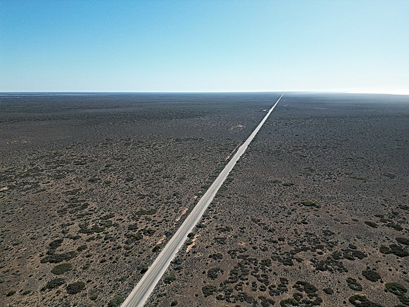
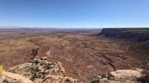
Moki Dugway is an iconic section of Highway 261 in Utah that offers one of the most thrilling and scenic drives in the United States. Carved into the face of Cedar Mesa, this gravel road features steep switchbacks, sharp turns, and panoramic views of the Valley of the Gods, Monument Valley, and the surrounding red rock desert. It’s not just a road—it’s an adventure that attracts tourists, off-roaders, and those looking for a taste of the untamed American West.
We visited Moki Dugway en route from Monument Valley to Natural Bridges National Monument, another incredible spot to experience Utah’s unique landscapes. We were driving our 1/2 ton rear wheel drive Ford F150. As we navigated the switchbacks and took in the expansive views, we were shocked to see a smashed up car that had fallen off the edge, resting precariously below the steep cliffs. While it was a stark reminder of how dangerous the road can be, it added an unexpected layer of intrigue to our adventure on this rugged route. There was plenty of graffiti and stickers at the top lookouts that suggest this could be a fun spot on a Saturday night!
The History and Purpose of Moki Dugway
Moki Dugway was originally constructed in 1958 by Texas Zinc Minerals, as part of the uranium mining boom in the American Southwest. It was built as a transport route for trucks carrying uranium ore from the Happy Jack Mine on Cedar Mesa to processing mills in Mexican Hat, Utah. The region around Cedar Mesa and southeastern Utah was a key area in America’s Cold War-era uranium mining efforts, driven by the demand for nuclear energy and weapons development. The dugway remains largely unchanged since that time, retaining its rugged and primitive charm, although its purpose has shifted from industrial transportation to a scenic route for travelers.
The name “Moki” is derived from the Spanish word “Moqui,” an early term for the indigenous Hopi people, while “dugway” refers to a road carved into a hillside, which is exactly what the Moki Dugway is—an impressive engineering feat that remains a testament to the region’s mining history.
Road and Elevation Details
- Length: 3 miles (4.8 kilometers)
- Elevation: 1,200 feet (366 meters) of elevation gain over a short distance
- Surface: Gravel road with no guardrails
- Maximum Grade: Approximately 11%
- Speed Limit: 5 to 10 mph on steep switchbacks
- Coordinates: Moki Dugway on Google Maps
The steep, unpaved road was specifically designed to accommodate large trucks transporting heavy uranium ore down from the mesa. It has since become a challenge and a point of interest for adventurous road trippers, although it remains unsuitable for large RVs (we passed an RV ascending..), trailers, and inexperienced drivers. Travelers are encouraged to use caution, particularly in wet or icy conditions.
Uranium Mining Legacy in Southeastern Utah
The uranium mining boom of the 1950s and 60s had a profound impact on the region surrounding Moki Dugway. Cedar Mesa was one of many sites in the American Southwest where companies mined uranium ore. Uranium miners, along with their equipment and ore, used Moki Dugway regularly, navigating the sharp switchbacks to deliver the valuable material to processing facilities. The Cold War saw a rush to secure domestic sources of uranium, and places like Utah became the epicenter of this industry.
Uranium mining left behind a complicated environmental legacy, including abandoned mines, radioactive waste, and other hazards. While many mines have since closed, their presence remains an indelible part of the region’s history.
Today, Moki Dugway is a reminder of the uranium boom’s industrial past, and although mining trucks no longer travel the route, the road remains as steep and precarious as it was when it was first constructed for heavy loads.
Moki Dugway as a Filming Location
The cinematic beauty of Moki Dugway has made it a favorite filming location for commercials, documentaries, and movies. Its vast, open desert vistas, steep cliffs, and switchbacks make it an ideal backdrop for depicting the rugged American West. The road has appeared in various car commercials, especially those featuring off-road vehicles, as the switchbacks and steep elevation changes showcase a vehicle’s endurance and capability.
Moki Dugway’s scenic location has also been featured in films that aim to capture the breathtaking and often desolate beauty of Utah’s red rock country. This area, with its combination of dramatic landscapes and remote isolation, has long been a favorite for Westerns and travel-related documentaries.
Driving Moki Dugway: What to Expect
As you ascend Moki Dugway, you’ll notice that the road cuts into the steep cliffside. The narrow switchbacks offer breathtaking views of the vast desert landscape below. On clear days, you can see for miles, with Monument Valley to the south and Valley of the Gods just beneath the mesa.
- Road Condition: The road is well-maintained but unpaved. It can be treacherous for larger vehicles or those not equipped for gravel surfaces. There are steep drops along the side, so careful navigation is essential.
- Best Vehicle Type: A high-clearance vehicle or four-wheel drive is recommended, especially in poor weather conditions. Though regular cars can manage the route in dry weather, anything larger than a small camper is discouraged.
One of the best parts of driving the Moki Dugway is the chance to stop and take in the views. There are several pullouts along the route where you can safely stop, step out of your car, and absorb the awe-inspiring scenery.
Nearby Attractions & Points of Interest
Moki Dugway is more than just a road; it’s a gateway to some of Utah’s most incredible natural attractions. If you’re making the journey, here are a few must-see stops:
- Valley of the Gods: A 17-mile loop drive through a landscape dotted with monoliths, mesas, and sandstone formations. It’s often compared to Monument Valley but with far fewer tourists. We were unimpressed with the view of the valley from the dugway, could see that it was a gravel road and chose to give it a miss this time. Valley of the Gods on Google Maps.
- Monument Valley: Located just south of the dugway, Monument Valley is one of the most iconic landscapes in the United States, with towering sandstone buttes. The area is known for its role in numerous Western films. Monument Valley on Google Maps.
- Goosenecks State Park: About 30 minutes from Moki Dugway, this park offers incredible views of the San Juan River’s serpentine path through deep canyon walls. It’s a great spot for photography and picnicking. We thought of staying here, but it’s first come first served with no hookups, and wanted a little more certainty for planning our visit. Goosenecks State Park on Google Maps.
- Mexican Hat: A small town named after a nearby rock formation that resembles a sombrero, Mexican Hat is a convenient place to stop for supplies or a meal before or after your Moki Dugway adventure. We picked up a Vanilla Coke and posted a postcard at the 7 eleven. Mexican Hat on Google Maps.
Safety Tips for Driving Moki Dugway
Although Moki Dugway is a beautiful drive, it can also be hazardous, especially for those unfamiliar with steep, narrow roads. Follow these safety tips to ensure a safe journey:
- Drive slowly: The speed limit is low for a reason. Keep your speed between 5-10 mph, especially around the sharp switchbacks.
- Avoid large vehicles: Large RVs or vehicles with trailers are not advised due to the tight turns and steep grade.
- Check the weather: Moki Dugway can become dangerous in wet, icy, or windy conditions. Check the weather forecast before your trip and avoid driving in bad conditions.
- Use pullouts: There are several pullouts along the route where you can safely stop and take in the views or allow other vehicles to pass.
Interesting Facts About Moki Dugway
- Meaning of “Dugway”: The term “dugway” refers to a road that has been dug out from the side of a cliff or hill. Moki Dugway is a prime example of this, offering steep cliffs and breathtaking views.
- Uranium Transport Route: The road was built specifically for uranium ore transport in the 1950s, playing a significant role in the mining industry during the Cold War era.
- Filming location: Moki Dugway has been featured in a number of commercials and films due to its stunning landscape and remote feel. Its iconic switchbacks and sweeping views provide a dramatic backdrop for off-road vehicle advertisements and adventure films.
- Annual visitors: While no exact figures exist, Moki Dugway attracts thousands of visitors each year, many of whom are road trippers or adventure seekers traveling through the Four Corners region.
Best Time to Visit Moki Dugway
The best time to visit Moki Dugway is during the spring and fall months when temperatures are mild. Summer can bring extreme heat, and winter can bring snow and ice, making the road more dangerous.
- Spring (March to May): Mild temperatures and blooming wildflowers make this a popular time for travelers.
- Fall (September to November): Cooler weather and fewer tourists make this one of the best times to visit – this is when we visited on our trip across America.
- Winter (December to February): Snow and ice are common, and the route may be closed or dangerous.
- Summer (June to August): Temperatures can exceed 100°F, so prepare for heat if you visit during this time.
Driving Moki Dugway: A Bucket List Adventure
For those who enjoy scenic byways and adventurous drives, Moki Dugway is a must-see. With its sweeping vistas, hairpin turns, and dramatic elevation changes, it offers an unforgettable experience that showcases the rugged beauty of Utah’s landscape.
Whether you’re exploring nearby attractions like Valley of the Gods or Monument Valley, or just seeking an off-the-beaten-path adventure, Moki Dugway is sure to be a highlight of your trip through the American Southwest.
So, if you’re planning your next road trip through Utah, be sure to add Moki Dugway to your itinerary.